La Gomera is a little island in the Canaries with spectacular long distance hiking. During our initial internet research for hiking options and possible routes, it was not easy to find a lot of information about the individual sections of the island’s two major long-distance routes.
To make it easier for interested hikers in the future, I took pictures of elevation profiles (for uphill/downhill gain information in both directions) and some maps on official signs along the way.
So, without further ado, here’s some information on Gran Ruta 131 “Camino Natural Cumbres de La Gomera” (“peaks of La Gomera”), and Gran Ruta 132 “Camino Natural Costas de La Gomera” (“coasts of La Gomera”).
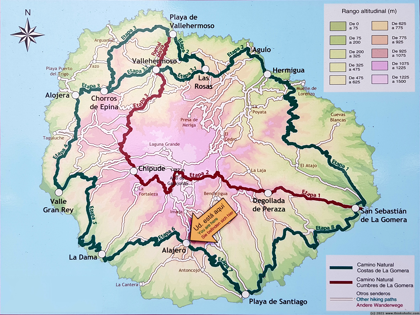
Overview map – GR131 and GR132

GR131 – Camino Natural Cumbres de La Gomera
Overview map and elevation profile for GR131:


Key information about the individual day sections:
| Day | Distance | Uphill gain | Walking time |
| 1: San Sebastián de La Gomera – Degollada de Peraza | 10.3 km | 1176 m | 4 h |
| 2: Degollada de Peraza to Chipude | 17.3 km | 1545 m | 6.5 h |
| 3: Chipude to Vallehermoso | 16.3 km | 712 m | 5.5 h |
| 3 extension: Vallehermoso to Playa de Vallehermoso | 3.7 km | 47 m | 1 h |
Visit Camino Natural Cumbres de La Gomera (Spanish only) or La Gomera , route The path Cumbre de La Gomera GR 131 for detailed route descriptions.
Day-by-day sections and elevation profiles for GR131:

GR131 day 1: San Sebastián de La Gomera to Degollada de Peraza – elevation profile

GR131 day 2: Degollada de Peraza to Chipude – elevation profile

GR131 day 3: Chipude to Vallehermoso – elevation profile

GR131 day 3 extension: Vallehermoso to Playa de Vallehermoso – elevation profile
GR132 – Camino Natural Costas de La Gomera
Overview map for GR132:
Key information about the individual day sections:
| Day | Distance | Uphill gain | Walking time |
| 1: San Sebastián de La Gomera – Hermigua | 26.7 km | 2035 m | 9 h |
| 2: Hermigua – Playa de Vallehermoso | 15.3 km | 1850 m | 6 h |
| 3.0 (main route): Playa de Vallehermoso – Alojera | 15.5 km | 1710 m | 6 h |
| 3.1 (alternate route): Las Rosas – Chorros de Epina – Alojera | 11.9 km | 1405 m | 5 h |
| 4: Alojera – Valle Gran Rey | 11.1 km | 1485 m | 4 h |
| 5: La Calera (Valle Gran Rey) – La Dama | 16.5 km | 1815 m | 6 h |
| 6: La Dama – Alajeró | 12.2 km | 1335 m | 4 h |
| 7: Alajeró – Playa de Santiago | 10.5 km | 850 m | 3 h |
| 8: Playa de Santiago – San Sebastián de La Gomera | 20.1 km | 1960 m | 8 h |
Visit GR 132 – Sendero Circular de La Gomera or La Gomera , route The path Costas de La Gomera GR132 for more details.
Day-by-day sections, elevation profiles, and some extra maps for GR132:
(Sadly, I seem to have missed the profile for day 7. If you have it, please consider sharing. :) )

GR132 day 1: San Sebastián de La Gomera to Hermigua – elevation profile

GR132 day 2: Hermigua to Playa de Vallehermoso – elevation profile

GR132 day 2 extra map: Hiking routes around Playa de Vallehermoso
: Playa de Vallehermoso to Alojera – elevation profile")
GR132 day 3a (main route): Playa de Vallehermoso to Alojera – elevation profile
: (Las Rosas to) Vallehermoso to Chorros de Epina – elevation profile (GR132.1)")
GR132 day 3b (alternate route): (Las Rosas to) Vallehermoso to Chorros de Epina – elevation profile (GR132.1)
: Vallehermoso to Chorros de Epina along PR LG 10 – extra profile (GR132.1)")
GR132 day 3b (alternate route): Vallehermoso to Chorros de Epina along PR LG 10 – extra profile (GR132.1)

GR132 day 4: Chorros de Epina to Valle Gran Rey – elevation profile
")
GR132 day 4 extra: Overview profile for Cruz de Tierno – Vallehermoso – Chorros de Epina – Alojera – Arure – La Mérica – Valle Gran Rey (elevation profile)

GR132 day 5: Valle Gran Rey to La Dama – elevation profile

GR132 day 5 extra map: Hiking route connecting Valle Gran Rey to La Dama and towards Alajeró

GR132 day 6: La Dama to Alajeró – elevation profile

GR132 day 8: Playa de Santiago to San Sebastián de La Gomera – elevation profile
Hiking blogs and trip reports
Here are some links to trip reports by fellow long distance hikers, who did various combinations of sections from both Caminos: